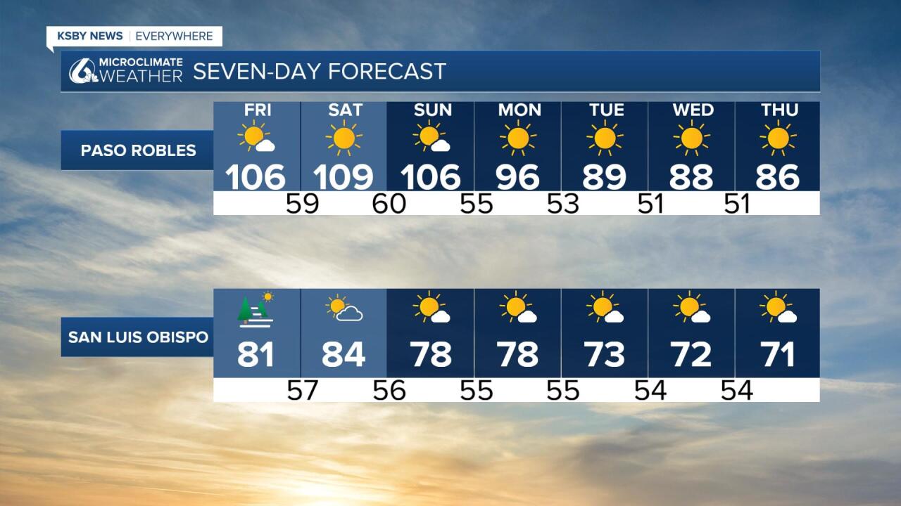
Forecast at a glance:
Extreme heat is building in the interior valleys today and will last through the weekend. The extreme heat has prompted a excessive heat warning to be issued for portions of San Luis Obispo County’s interior valleys. Coastal regions will see more marine fog each morning that will keep temps slightly lower.

———Original Story———
Good morning, Central Coast!
It is going to be a very warm one out there today so let’s dive right in.
Dense fog is in place along our coastal valleys this morning, that will keep temps significantly cooler today but also limit visibility on many roadways.

Due to the dense fog there is a fog advisory in place for our beaches and coastal valleys through 10 a.m.

Where the marine influence persists along our coasts temps will warm slightly from the previous days but still be very comfortable on the whole. In the interior valleys where the cooler marine air was unable to reach this morning temps will warm up significantly and bring significant heat risk.

The heat in the interiors is intense enough that there are several warnings and advisories in place.
For the San Luis Obispo county interiors highs will reach upwards of 105 degrees. That has warranted a excessive heat warning to be issued by the National Weather Service. That warning will stay in place through 8 p.m. Sunday night.

For southern San Luis Obispo county a high heat advisory is in place through Sunday night as well. In this area temps will be *slightly* cooler than in northern SLO county but no matter what portion of these advisories you are in the heat is dangerous for sensitive groups.

Overnight low temperatures in some locations will offer little reprieve from the heat with temperatures only cooling to around 70 degrees.
Coastal valleys and beaches will also see some warming but it looks to be pretty minor. The reason for the muted changes at the coast is the continued effect of the marine layer. Night and morning clouds with afternoon clearing can be expected for the next few days.
By the end of the weekend the high pressure driving this system will weaken and give way to a cooler air mass that will decent from the North Pacific. This will once again strengthen the marine influence so that it is able to reach into the interior valleys once again. This will cool temps significantly and take temps closer (but not all the way) to normal by the 4th of July.


Diving into the forecast for July 4th, temps look to be comfortable, especially compared to what we have seen recently. 60s along the beaches, 70s for the coastal valleys, and Southcoast, and 80s for the interiors.
The low pressure and marine influence that will help keep temps more comfortable for the 4th also means that cloud cover is a concern for evening firework displays. I think that it is too early to call it but clouds will likely be high enough to not tamper too much with the evening festivities. That being said this far out things are bound to change. The first look weather team will be keeping a close eye on the finer points of that cloud cover as the forecast comes into more detail.
Have a wonderful day Central Coast!
